LATITUDES AND LONGITUDES
Globe is a true model of the Earth.
A needle is fixed through the globe in a tilted manner, which is called its axis.
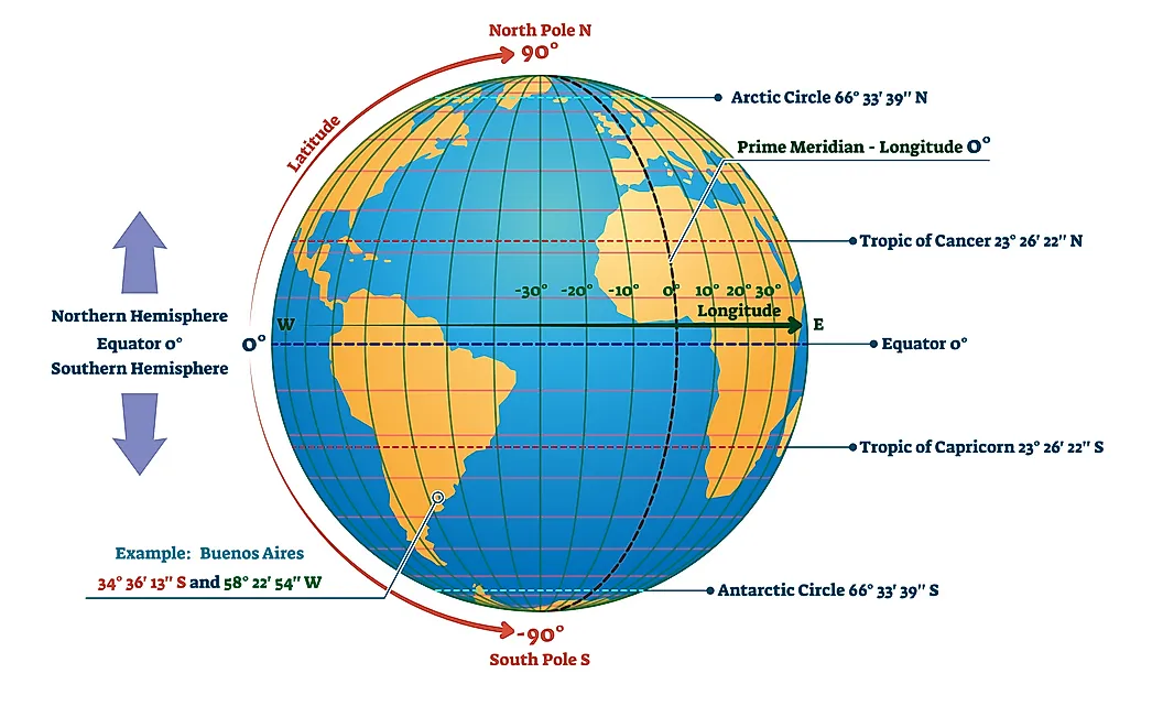
The imaginary line running on the globe divides it into equal parts. This line is known as the Equator.
All parallel circles from the Equator up to the poles are called parallels of latitude. Latitude is measured in degrees.
As we move away from the Equator, the size of the parallels of latitude decreases.
The four important parallels of latitude are :
- Tropic of Cancer (23
12 °N) - Tropic of Capricorn (23
12 2°S) - Arctic of Circle (66
12 °N) - Antarctic Circle (66
12 °S)
The equator represents the zero degrees latitude. The latitudes in the Northern Hemisphere are designated as degrees north (°N), e.g. 10°N, 20°N, and so on till 90°N (which is the North Pole). Similarly the latitudes in the Southern Hemisphere are designated as degrees south (°S), and 90°S is the South Pole.
Heat Zones of the Earth
- Torrid zone receives the maximum heat.
- The temperate zone has a moderate temperature.
- The frigid zone has a cold climate as the sun rays are always slanting.

Longitudes
- The line of reference running from the North Pole to the South Pole is called Meridians of Longitude.
- The distance between them is measured in ‘degrees of longitude’.
- All meridians are of equal length.
- The meridian which passes through Greenwich, where the British Royal Observatory is located, is called the Prime Meridian.
- The value of Prime Meridian is 0° longitude and from it, we count 180° Eastward as well as 180° Westward.
- Prime Meridian divides the earth into two equal halves, the Eastern Hemisphere and the Western Hemisphere.
- 180° East and 180° West meridians are on the same line.
- We can locate any point on the globe if we know its latitude and longitude.

Longitude and Time
- As the earth rotates from West to East, those places East of Greenwich will be ahead of Greenwich time and those to the West will be behind it.
- The earth rotates 360° in about 24 hours.
- At any place, a watch can be adjusted to read at 12 o’clock when the Sun is at the highest point in the sky.
Standard Time
- The local time various places are different, so it is necessary to adopt the local time of some central meridian of a country as the Standard Time.
- 82
12 °E is treated as the Standard Meridian of India. The local time at this meridian is known as the Indian Standard Time (IST). - India located East of Greenwich at 82° 30’E, is 5 hours and 30 minutes ahead of GMT.
- Some countries have a great longitudinal extent and so they have adopted more than one standard time.


